Connecting you with hundreds of data layers for better informed decisions, InfoTrack’s mapping tools enable you to easily locate, map, and explore any property boundary.
Conveyancing Mapping Tools
Get more from your mapping with intelligent data layers
It's essential for you to easily locate and investigate a site before you begin ordering searches. We also understand the importance of identifying risks and hazards associated with the intended use of a site. The process should be simple and accurate, but that isn't always the case.
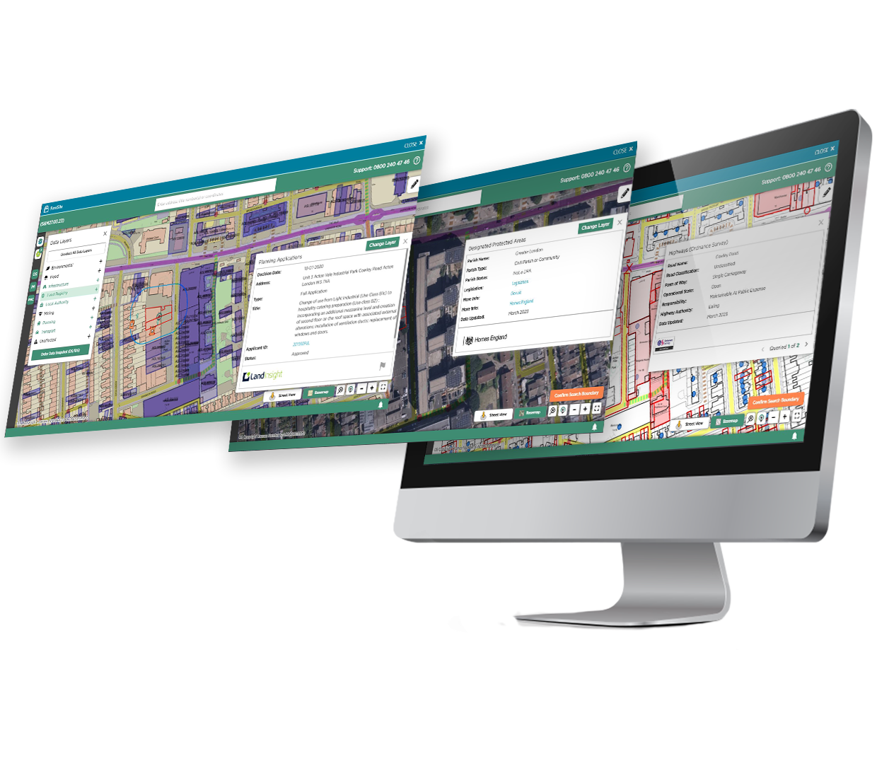
Our intuitive mapping tools simplify the process by accessing the Land Registry National Polygon Dataset and hundreds of data mapping layers so you can access the information you need. Combined with our pre-search due diligence tools, you can access the key details you need about a site from the outset.
With InfoTrack's commercial mapping tools, you can quote more accurately, identify hazards or risks early in the process, and ultimately win more work.

Benefits of ForeSite Commercial Mapping
Better data means better-informed decisions. Connecting you with reliable data and insights you can act on, InfoTrack helps you access the information you need early in the due diligence process. Giving you greater visibility and helping you to manage expectations, our integrated mapping tools can improve your commercial property transactions by:
- Providing 100+ crucial data layers overlaid on street view, black and white, colour maps, and more.
- Enabling you to identify risks early and extract all relevant hazards and digital data sets in just three clicks.
- Creating a collaborative workspace with annotations and highlighted risks to share with your developer clients through an interactive and shareable report.
- Digitising Title and Ownership information with illustrative maps using interactive visualisation for easy-to-view insight.
- Facilitating faster risk assessments to make data-driven decisions for a better client experience, including improved quote accuracy.
- Providing easy-to-use drop and drag functionality to map boundaries in seconds.
Features of ForeSite
- Illustrative maps that bring titles to life, helping you to visualise titles and provide insight about land composition.
- An interactive mapping workspace that eliminates multiple hard copy references, so you can instantly plot your titles directly on a digital map.
- Data Snapshot allows you to create rapid risk assessments before searches are ordered so you’re informed early on.
- Company Ownership information is available at the start of a transaction with our Proprietor Name Check (PNC) so you can identify properties owned or mortgaged by a specific company.
Take the next step
Book a 15-minute demo with one of our commercial property experts to discuss how our innovative mapping tools can help you tackle complex projects more easily.

Flexible searching
Gain access to more than 100 data sources for overlaid information on our mapping solution encompassing the following data sets:
- Planning Applications
- Registered Boundaries
- Highways
- Listed Buildings
- Designated Protected Areas
- Tree Preservation Orders
- Conservation Areas
- Freeport and Tax Custom Sites
- And more...
"The new mapping and data layer tools have allowed us to gain insight ahead of advising clients on land holdings. The ability to switch the different data layers on and off means we can be specific in the requests made and data returned – a real game charge for large acquisition sites. Using HMLR polygons or drawing your own allows flexibility when identifying search areas."
"We're very impressed with InfoTrack, it's highly intuitive and user-friendly. The pre-search insight tools enable us to quickly check for any ‘red flag’ issues and raise them with our clients before the cost of a full suite of searches is incurred. The drag-and-drop feature for plans and SIM searches and the ability to quickly create illustrative plans of large development sites allows us to order searches both accurately and efficiently."
"A huge part of being able to offer strategic real estate advice is having a good overall understanding of a property, its surrounding features, and any potential issues early on. InfoTrack’s mapping tools and data layers, combined with the ease of locating a property via address/title search or a dragged and dropped plan, make this instantly possible at the outset of a transaction, improving both the speed and quality of advice to our clients."